
Chorro Creek Floodplain Resilience

In 2023, CSLRCD was awarded funds from the State Coastal Conservancy to increase coastal resilience and reduce flooding in the lower Chorro Creek watershed through the Lower Chorro Creek Watershed Floodplain Resilience Planning Project.
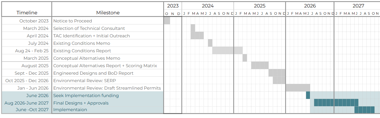
CSLRCD staff and technical consultant Stillwater Sciences made significant progress on the project in 2024 and 2025. After months of topographic surveys, data collection and iterative review by the technical advisory committee, the project team released the Existing Conditions Report in September, including geomorphic assessments, biological resources indexes, and hydraulic and hydrologic modeling of current and projected conditions under projected sea level rise scenarios. Find the Sediment Transport Memo here.

Concurrent with the development of the Existing Conditions Report, the project team conducted extensive stakeholder outreach, hosting community meetings and going door-to-door, discussing the project and its anticipated outcomes with both public and private landowners, including residents on Chorro Creek road who suffered catastrophic flooding in 2023.

The project has received positive support in the community, and in 2025, the project team began developing Conceptual Design Alternatives for over 25 individual sites across the project area, including CSLRCDs floodplain property, Chorro Flats. Design alternatives are based on natural systems and solutions, increasing floodplain resilience for the benefit of aquatic resources and protection of coastal communities and infrastructure. Alternatives include vegetation management, stream channel enhancement, ecotone fill, drainage improvements, berm setbacks, and wetland enhancements.
Incorporating feedback from the community, regulatory agencies, funders, and the Technical Advisory Committee, the project team has selected the priority sites that will be advanced through final engineering and environmental review in 2026 followed by implementation in 2027 and 2028.
Sites include Seasonal wetland enhancements on Chorro Flats, relocation of a riparian well, floodplain enhancement at the confluence of Chorro and San Bernardo Creek, vegetated swale creation through agricultural fields, and drainage improvements in the Chorro Creek Road neighborhood.
CSLRCD will seek implementation funding through new Prop 4 allocations.
See the project timeline below:
Check out the news clip below done by Community News Reportor, Sophia Villalba of KSBY!
-August 12th, 2025
Existing Conditions ReportSediment Transport MemoConceptual Design Alternatives
Partners: Ca State Parks, CalTrans, SLO Co, Stillwater Sciences, & SLOCOG
Funders: State Coastal Conservancy & Morro Bay National Estuary Program
RCD Contact: Hallie Richard, hrichard@coastalrcd.org